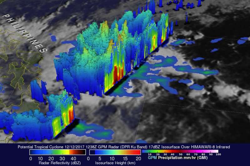
NASA looks at rainfall in developing Tropical Storm Kai-tak

Tropical Storm Kai-tak developed near the east central Philippines as the Global Precipitation Measurement mission or GPM core satellite passed overhead and analyzed its rainfall.
The GPM core observatory satellite carries the first space-borne Ku/Ka-band Dual-frequency Precipitation Radar (DPR) and a multi-channel GPM Microwave Imager (GMI). GPM is a joint mission between NASA and the Japanese space agency JAXA.
The GPM satellite traveled over the Philippine Sea on December 12, 2017 at 7:38 a.m. EST (1238 UTC). The satellite's GMI and DPR instruments collected data showing that strong convective storms in the area were producing heavy precipitation. GPM's radar (DPR Ku band) data showed that a few of the most intense storms were dropping rain at a rate of greater than 143 mm (5.6 inches) per hour.
GPM's radar (DPR Ku band) provided 3-D measurements of precipitation structure within the developing depression in the Philippine Sea. The storms were probed within the 245 km (152 mile) swath scanned by GPM's Ku band radar. Several of the powerful storms in the area were found by GPM's radar to reach altitudes greater than 16 km (9.92 miles).
On Dec. 14, Philippines warnings were posted for Tropical depression Kai-tak. Public storm warning signal #2 is in effect for the Visayas provinces of Eastern Samar, Samar, Biliran. Public storm warning signal #1 is in effect for the Luzon provinces of Catanduanes, Camarines Sur, Albay, Sorsogon, Masbate and Romblon; and for the Visayas provinces of Northern Samar, Leyte, and Southern Leyte, Northern Cebu including Bantayan Island, Capiz, Aklan and Northern Iloilo.
On Dec. 14 at 10 a.m. EST (1500 UTC) Tropical Storm Kai-tak, formerly System 96W was located near 11.6 degrees north latitude and 127.6 degrees east longitude, about 433 nautical miles east-southeast of Manila, Philippines. Kai-tak was moving to the west at 2 knots (2.3 mph/3.7 kph), through the central Philippines. Maximum sustained winds were near 35 knots (40 mph/62 kph).
On Dec. 14 at 4:58 a.m. EST (0958 UTC) a Special Sensor Microwave Imager Sounder (SSMIS) image showed a slightly improved organization with strong bands of thunderstorms banding over the northern quadrant wrapping into the southwest quadrant of the system. Animated radar imagery from the Philippine Atmospheric Geophysical and Astronomical Services Administration or PAGASA showed heavy rain bands persisting over the central Philippines.
Kai-tak is forecast to move westward through the Philippine archipelago over the next couple of days.
Provided by NASA's Goddard Space Flight Center


