To use this site, please disable the ad blocking feature and reload the page.
This website uses cookies to collect information about your visit for purposes such as showing you personalized ads and content, and analyzing our website traffic. By clicking “Accept all,” you will allow the use of these cookies.
Users accessing this site from EEA countries and UK are unable to view this site without your consent. We apologize for any inconvenience caused.
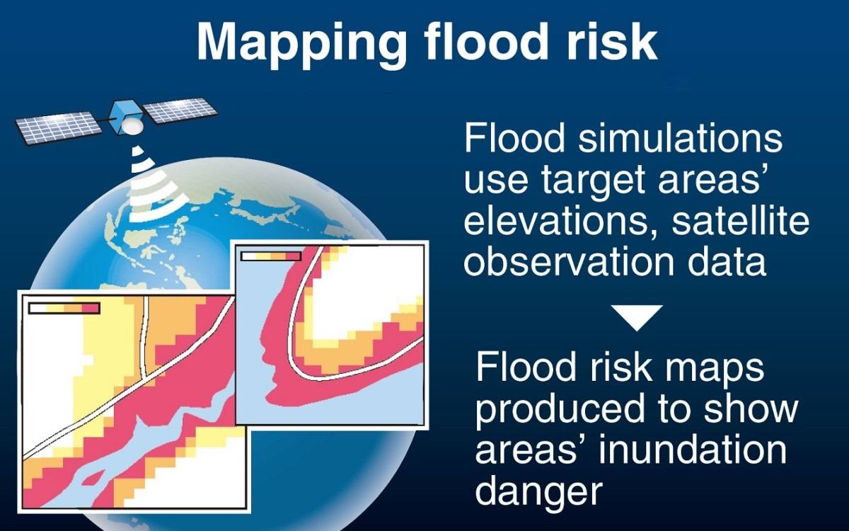
Japan’s land ministry plans to start providing flood risk maps to Indonesia, Thailand, Cambodia and Vietnam next fiscal year to help the Southeast Asian countries reduce damage from flooding. The maps will use satellite observation data to predict flooding caused by heavy rainfall.
The initiative aims to boost Japan’s involvement with the emerging and developing countries collectively known as the Global South and counter China, which is increasing its influence on various countries.
The Land, Infrastructure, Transport and Tourism Ministry already publishes flood risk maps for various parts of Japan, showing the frequency and depth of inundation caused by flooding. Based on observation data collected on the ground, including by rainfall gauges, the maps show the risk of inundation from heavy rainfall likely to occur every 10, 30, 50, 100 and 150 or 200 years, with the information to be used to facilitate smooth evacuation and community planning.
The four Southeast Asian countries are frequently hit by large-scale flooding. This prompted the ministry to think that it would be useful for them to have similar maps that clearly show the risk of flooding in target areas. Because these countries do not have sufficient ground-based observation data, the ministry decided to create maps of specific areas after simulating floods using observation data collected by the Global Satellite Mapping of Precipitation (GSMaP) system, operated by the Japan Aerospace Exploration Agency and others.
The ministry began discussions with the four countries in fiscal 2023 to select the target areas. It plans to provide a prototype version of the map to each country by the end of fiscal 2025.
In addition to preparing guidelines, which include procedures for creating maps, the ministry will also develop human resources through training programs.
The maps are expected to be made available to the public in each country. As many Japanese companies operate in the four countries, it is also expected that the maps will help them draw up business plans in preparation for disasters and select their office or factory locations.
The ministry is also considering providing the maps to other countries.