NASA finds heavy rain in new Tropical Cyclone Hola near Vanuatu

NASA obtained rainfall data on newly formed Tropical Cyclone Hola as it triggered warnings in Vanuatu in the South Pacific Ocean.
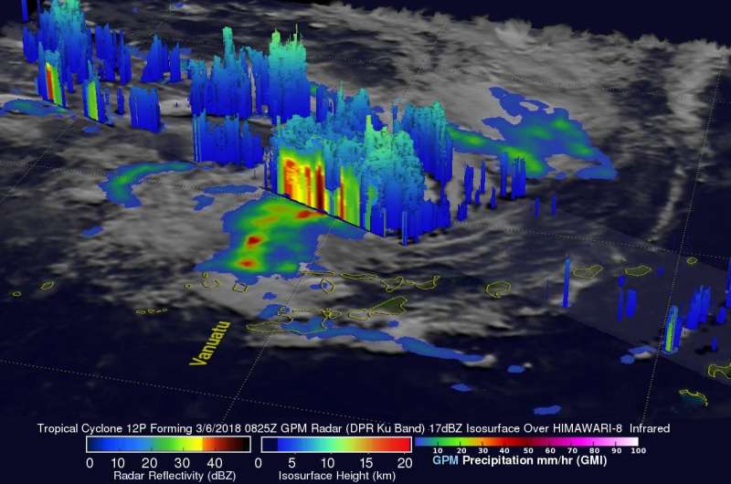
On March 6, 2018 at 3:25 a.m. EST (0825 UTC) the GPM or Global Precipitation Measurement mission core observatory satellite flew above a forming tropical cyclone in the southern Pacific Ocean just east of Vanuatu.
GPM's Dual Frequency Precipitation Radar (DPR) scanned storms in the center of forming Tropical Cyclone Hola's circulation. This view by GPM's DPR revealed that convective storms were dropping extremely heavy rainfall on the eastern edge of the forming tropical cyclone's low level center. DPR indicated that rain was falling at a rate of over 241 mm (9.5 inches) per hour in this area.
The use of GPM satellite's radar data enabled this 3-D view of the forming tropical cyclone's precipitation. These probes of tropical cyclone Hola showed the heights of precipitation within the convective storms wrapping around the forming tropical cyclone's low level center of circulation. GPM's radar clearly showed that some tall storms on the eastern edge of Hola's center of circulation were reaching heights above 12 km (7.4 miles). GPM is a joint mission between NASA and the Japan Aerospace Exploration Agency, JAXA.
On March 7, in Vanuatu there is a tropical cyclone warning is in effect for the Penama, Sanma, Malampa and Shefa provinces.
At 4 a.m. EST (0900 UTC) on March 7, 2018, Tropical Cyclone Hola had maximum sustained winds near 55 knots (63.2 mph/102 kph). It was centered about 125 nautical miles northwest of Port Vila, Vanuatu, near 16.1 degrees south latitude and 166.9 degrees east longitude. Hola was moving to the west at 7 knots (8 mph/13 kph).
The Joint Typhoon Warning Center (JTWC) noted that Hola is expected to intensify to hurricane within the next few days. Hola is forecast to move toward the west-southwest over southern Vanuatu. Hola is then expected to round the sub-tropical ridge and move south-southeastward toward northern New Zealand.
Provided by NASA's Goddard Space Flight Center


